
Pilot Service Urban Heat – Bringing climate insights to the neighbourhood scale
Delivering local climate information for cities to mitigate and adapt to the impacts of climate change.
Main contractor: VITO Vlaamse Instelling voor Technologisch Onderzoek, Flemish Institute for Technological Research (Belgium)
What is it? A Urban Heat Pilot Service, combining data from the Climate Change Adaptation Digital Twin (Climate DT) with advanced urban climate models to deliver local climate information. The project will develop a service for climate and urban heat data at 100-200 meters spatial resolution – the scale where impacts are truly felt.
Concrete applications examples:
Heat stress affects public health, infrastructure, and productivity, particularly during prolonged heatwaves. By providing detailed heat risk indicators, cities can mitigate and adapt, for example by designing cooler public spaces, identifying vulnerable populations, and supporting emergency response and public health decisions.
Main target end users:
City administrations, decision makers designing resilience strategies, architects, urban planners, and public health authorities. The service is being co-designed with major European city networks, including Resilient Cities Network (RCN), Climate Alliance, ICLEI, and Euro Cities to ensure it meets real-world needs.
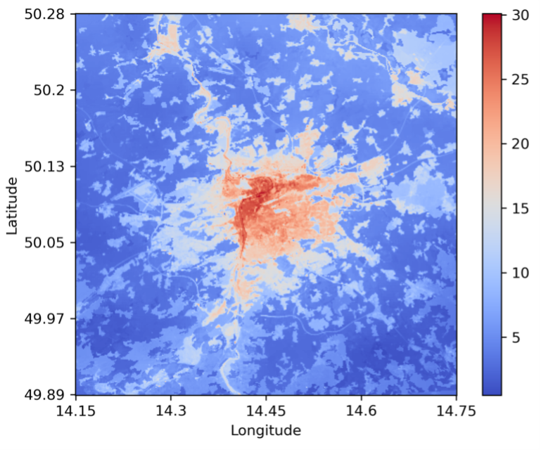
Example output map of the UrbClim model, performing model simulations for the reference period (2011-2020). The maps shows the annual number of tropical nights, defined as nights during which the 2m air temperature was always above 20°C, for the city of Prague. Source: VITO.
Pilot urban heat service – Detailed urban heat information supporting adaptation
Urban heat is becoming a critical issue, and a growing number of cities in Europe and across the worldwide are adopting resilience plans. Local authorities and stakeholders increasingly demand tailored data and services to support local action. With heatwaves emerging as becoming one of the most significant climate-change-related risks in urban areas, decision-makers aim to better understand their impacts on public health and economy. For this DestinE Pilot Service, VITO is partnering with Spain’s Tecnalia and several city networks to integrate Climate DT scenarios in an advanced urban heat service.
The pilot service will provide a wide array of urban heat related information (indices) at a resolution of around 100 to 200 meters, reaching a “neighbourhood scale”. This level of detail is not only a technological and scientific achievement but also a key feature to support effective heat stress adaptation.
For this new pilot service, VITO and Tecnalia will integrate data from various scenarios produced by the Climate DT,extracting them from DestinE’s Data Lake. The pilot service will be accessible via the DestinE Service Platform.
It will deliver key heat stress indicators, including impact indicators like urban heat island intensity, number of health heatwave days, heat-related mortality, lost working hours, and cool island identification.
In addition, the setup will allow the provision of information at street-level for parameters such as the Wet Bulb Globe Temperature and Universal Thermal Climate Index. These will be available as a downloadable data packages for selected cases, in principle supporting specialized consulting services on this basis.
The system’s performance will be compared with the current industry standard, which is based on downscaling of the CMIP6 ensemble of global climate models.
A newly developed interface will collect user requirements in terms of parameters for urban climate simulations and analyses ensuring direct feedback and codesign with users. Once a simulation is completed, the resulting mapping data will be available via DestinE Data Lake for visualisation and further analysis by users.
Four city networks will participate in the codesign and be the final users of this pilot service: the Resilient Cities Network (RCN), Climate Alliance, Local Governments for Sustainability (ICLEI) and Euro Cities. This approach ensures that the system responds to the final users’ requirements and fulfills their needs.
The Pilot Service for Urban Heat continues the developments initiated during a previous use case of DestinE, also also led by VITO and Tecnalia, which confirmed the strong interest of local authorities in such a service.
ECMWF, as a key implementing entity of the Destination Earth initiative of the European Union, has issued a series of pilot services contracts that demonstrate the added value of the Weather-Induced Extremes Digital Twin and the Climate Change Adaptation Digital Twin, and the wider DestinE architecture. The key target users of the pilot services are the sectors most impacted by climate change and weather extremes, such as maritime operations, coastal areas, energy, and more. The contracts include a specific call for machine learning and artificial intelligence-based proposals as a part of the implementation of ML/AI techniques within the Destination Earth initiative of the European Commission, led by DG CNECT, and implemented by ECMWF, EUMETSAT, ESA and over 100 partner institutions across Europe.
Copyright title image: AdobeStock – miss irine