Adaptation Modelling Framework for Heat Stress Exposure
November 2023 - April 2025
TECNALIA* research organisation uses Destination Earth’s Climate Adaptation digital twin (Climate DT) to develop an interactive tool supporting decision-makers in the assessment of different adaptation.
This use case ran from November 2023 – April 2025 and is now closed.
TECNALIA* research organisation used Destination Earth’s Climate Adaptation Digital Twin (Climate DT) to develop an interactive tool supporting decision-makers in the assessment of different adaptation options for heat stress adaptation under climate change scenarios, with a special focus on public health management.
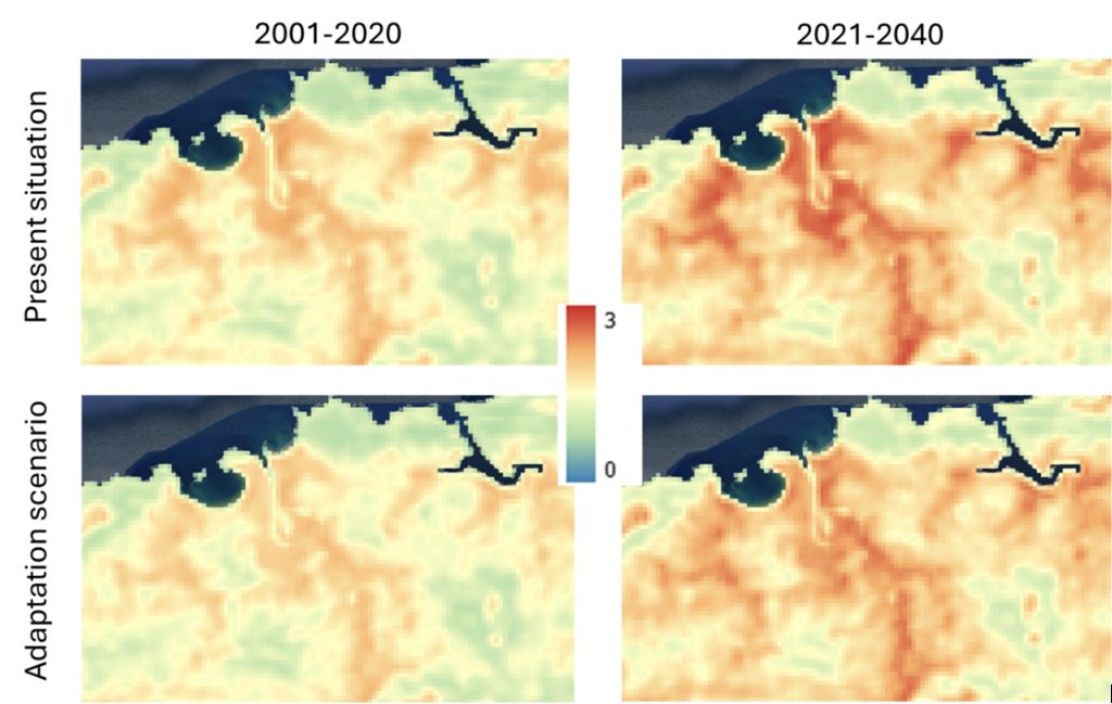
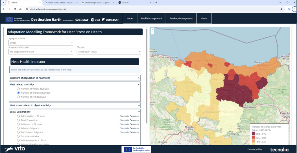
The tool produces high-resolution spatial map (100m) that are combined with socio-economic data and health determinants (age, income, etc.), to allow for the analysis of vulnerability and potential impact (risk) at health areas units of the Basque Country.
This empowers health manager, urban planners and territorial managers to design more resilient, climate-smart urban environments and communities, ensuring they are better prepared for the challenges of a changing climate.
Heat stress in context
Extreme heat events are becoming more frequent and intense posing serious health risks in in Spain [1] and Europe [2]. According to the World Health Organization, the number of people exposed to heat waves increased by around 125 million between 2000 and 2016.
Heat stress will cause devastating health impacts on growing urban and ageing populations, particularly threatening vulnerable populations (see also EEA report). A recent paper estimates over 70,000 deaths related to high temperatures during summer 2022 across Europe.
These effects are amplified in urban areas due to the urban heat island effect – due to the lack of green spaces, dense development, and materials like concrete and asphalt that trap heat, making heat-stress more intense.
These impacts depend on local factors such as exposure, vulnerability to climate-related stress and the implementation of efficient resilient policies. Well-prepared health systems and well-suited adaptation measures at different levels are essential to protect populations, limit the adverse impacts of heat and therefore reduce risks.
A trustworthy and accurate operational system using DestinE’s Climate Adaptation Digital Twin
To effectively assess and address heat stress exposure on populations, it’s essential to develop georeferenced heat-stress exposure maps that enable stakeholders to implement targeted adaptation measures.
Current information and simulation models about heat stress exposure are limited in time and space due to the high computational costs, making it sometimes too complex for stakeholders to have accurate assessment of heat stress. The UrbClim model has been selected because it strikes a balance between spatial accuracy and computational efficiency, allowing for the simulation of urban heat-stress and other critical heat-related health indicators over large areas and long time periods, including the capacity to perform climate change analysis. UrbClim simulation outcomes are combined with a tailored AI/ML model to upscale simulation outcomes for individual areas to the full region and provide a flexible effectiveness model able to integrate and run adaptation scenarios and predict how heat stress will evolve under different climate conditions.
Having Climate DT data and federated providers such as Copernicus data or many other sources in a unique and harmonized access point (DEDL) facilitates focusing the efforts on the development, improvement, and assessment of higher quality and more accurate products. This is particularly important for territorial-scale adaptation planning, where comprehensive, actionable insights are needed to implement effective Nature-based Solutions (NbS) and other adaptation measures.
Technical solution
The Heat Stress Adaptation Tool, developed by Tecnalia as part of the Destination Earth program, helps identify high-risk areas and vulnerable populations by considering socio-economic and health determinants. It can model current and future climate conditions using data from the Climate Digital Twin (Climate DT) and simulate the impact of various adaptation strategies, including:
- As well as assigned system risk tolerance by changing threshold values to health risk indicators.
- Planting trees in street and avenues.
- Naturalization of open spaces or adding vegetation on roofs;
- It can also test how the development of urban parks and community gardens can contribute to reduce heat-stress;
- The use of materials that reflect solar radiation in roofs and facades;
- Incorporation of water features in open spaces, such as fountains, or lakes and large ponds into peri-urban areas;
- As well as assigned system risk tolerance by changing threshold values to health risk indicators.
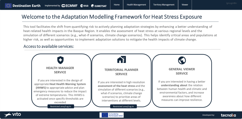
]The tool empowers health manager, urban planners and territorial managers to design more resilient, climate-smart urban environments and communities, ensuring they are better prepared for the challenges of a changing climate.
If you want to dive deeper into this application, find out more here.
Contribution to the adaptation modelling framework
Throughout this contract Tecnalia has contributed to design a Generic Adaptation Modelling Framework (GAMF) aiming to support EU Adaptation Strategy goals and enable easier access to advanced hazard and impact models for decision-makers.
The Generic Adaptation Modelling Framework (GAMF) describes the process to develop an adaptation modelling system by leveraging state-of-the-art developments from Destination Earth. So, each step of the process is explained together with the DestinE resources available to empower expert users and developers in harnessing digital twin technology.
This framework has been designed as a modular approach to fosters collaboration, innovation, and knowledge exchange, ensuring continuous evolution of DestinE to address emerging needs and incorporate the latest scientific advancements in climate adaptation and mitigation efforts.
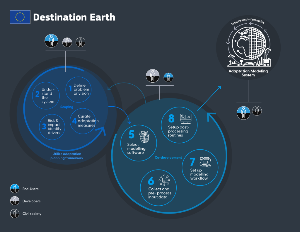
Tecnalia collaborated closely with Deltares to design the framework based on experiences and information gathered on the heat stress exposure and flood risk management use cases. Following a co-design approach, they engaged stakeholders through webinars and meetings and incorporated their feedback.
If you want to dive deeper into how these two use cases have implemented the GAMF please check out the story map and watch the video below.
A team of experts gathered to demonstrate the value of the Climate DT
In order to achieve the ambitious objectives of this use case TECNALIA has set up a consortium composed of members of its Climate Change Adaptation team Urban Transformation Lab of TECNALIA with vast experience developing projects for regional and local authorities related to climate resilience and members from VITO Climate Impacts group (CLIM), complemented by members from the business unit of VITO “Environmental Modelling (VITO-RMA)” with expertise in quantitative assessment of climate related impacts and has recently been contracted by ECMWF to develop a use case to tackle urban heat islands.
* TECNALIA is a member of the Basque Research and Technology Alliance
[1] Considering the whole 2023 summer, temperature-related deaths in Spain were 3,009, with 169 occurring in Basque Region.
[2] In 2022 Europa had 61.672 deaths due to heat. Ballester, J., Quijal-Zamorano, M., Méndez Turrubiates, R.F. et al. Heat-related mortality in Europe during the summer of 2022. Nat Med 29, 1857–1866 (2023). https://doi.org/10.1038/s41591-023-02419-z
Destination Earth is a European Union funded initiative launched in 2022, with the aim to build a digital replica of the Earth system by 2030. The initiative is being jointly implemented by three entrusted entities: the European Centre for Medium-Range Weather Forecasts (ECMWF) responsible for the creation of the first two ‘digital twins’ and the ‘Digital Twin Engine’, the European Space Agency (ESA) responsible for building the ‘Core Service Platform’, and the European Organisation for the Exploitation of Meteorological Satellites (EUMETSAT), responsible for the creation of the ‘Data Lake’.
More information about Destination Earth on the EU Commission website
More information about Destination Earth on the EU Commission website
For more information about ECMWF’s role visit ecmwf.int/DestinE