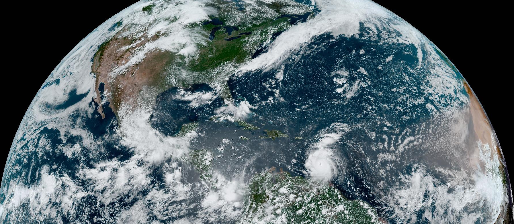
The simulations at an enhanced resolution of 4.4km carried out at the European Centre for Medium-Range Weather Forecasts (ECMWF) in the framework of Destination Earth (DestinE), were shown to improve the representation of tropical cyclones in particular under rapid intensification conditions, and certain extreme precipitation episodes. This was also the case for the early stages of hurricane Beryl that hit the Caribbean at the end of June – early July 2024.
A preliminary evaluation of the global component of the Weather-induced Extremes Digital Twin (Extremes DT), developed by ECMWF in DestinE, found improvements in the representation of certain extreme weather phenomena, particularly tropical cyclones and extreme precipitation. The ECMWF Integrated Forecasting System (IFS) run at 4.4 km resolution (compared to 9 km for the operational ECMWF forecasts) improved the intensity of tropical cyclones undergoing rapid intensification. In addition, the analysis found that extreme precipitation in orographic environments was generally better represented in the 4.4 km forecasts, benefitting from the steeper slopes of the model orography.
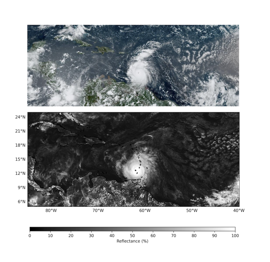
The teams at ECMWF could for example demonstrate the benefit of simulating hurricane Beryl at 4.4 km resolution. The ECMWF operational forecasts at 9 km resolution began capturing the system on 29 June at 00 UTC and represented well the development of the early stages of the hurricane, in terms of track, but it considerably underestimated its intensity. The predictions for the cyclone’s intensity, in terms of minimum mean sea-level pressure and wind strength, as Beryl approached North Grenada, were better represented from the very early stages in the 4.4 km prototype simulations of the Destination Earth Weather-induced extremes Digital Twin (Extremes DT). An example is shown below with the DestinE simulation at 4.4 km and the control of our operational ECMWF ensemble forecasts, initialised on 30 June at 00 UTC.
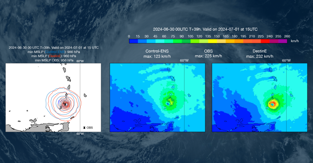
The simulation of Beryl, an intense but relatively small-scale system, illustrates how enhanced horizontal resolution improves certain aspects of the representation tropical cyclones, and therefore can bring significant benefits predicting such extreme weather events.
Promising results from prototype simulations of the DestinE Extremes DT
In the framework of the Destination Earth (DestinE) initiative of the European Commission, ECMWF, together with partners from national weather services and academia across Europe, is developing a digital twin focused on weather-induced extreme events.
This digital twin has a global component, developed by ECMWF using its Integrated Forecasting system at a resolution of 4.4 km, and a regional component allowing users to zoom over Europe at resolutions of a few hundred meters, developed by a European partnership led by Météo-France.
ECMWF has carried out a preliminary evaluation of the global component of the Extremes DT based on approximately 8 months of daily four days forecasts (between 23 August 2023 – 2 May 2024 on ECMWF Atos supercomputer), with a specific focus on specific extreme events of particular interest for the development of the Extremes DT. Since December 2023, daily runs have been performed regularly in the EuroHPC Joint Undertaking’s LUMI supercomputer.
The accurate prediction of hurricane Beryl’s intensity in the Extremes DT forecast is not purely coincidental. Analyzing the results of daily forecasts initialized during the tropical cyclone active season in the northern hemisphere reveals a clear pattern of enhanced tropical cyclone intensity and wind speed, resulting in reduced forecast errors in the DestinE 4.4km simulations compared to the ECMWF operational forecast at 9 km resolution, as shown in the chart below.
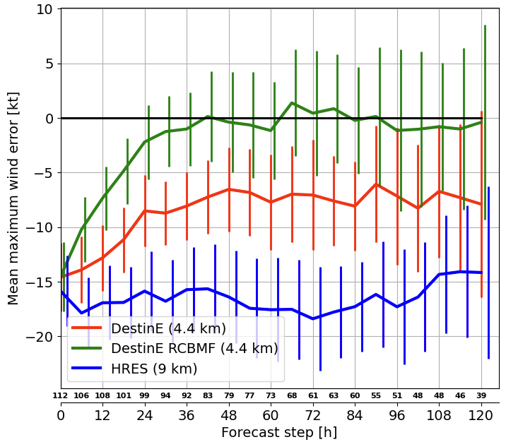
Further improvements can be achieved by decreasing the reliance on the deep convection scheme to account for the partially resolved convection at km-scale. In practice, this is done by reducing the cloud base convective mass flux in the convection scheme, and it results in a better representation of tropical convection (as per a research in preparation by Becker et al.) and further reduces the maximum wind error of tropical cyclones. It should be noted that the error at step 0 in the chart above is a consequence of TC intensity errors in the operational analysis. According to some preliminary experiments done in DestinE and not shown here, a stronger intensity of tropical cyclones can be obtained in the analysis by increasing the resolution of the background trajectory and the data assimilation system.
Predicting tropical cyclones in the tropical Atlantic ocean more accurately allows a better assessment of their potential damage but also a better predictiction of the weather in Europe, as tropical cyclones often impact weather conditions in Europe a few days later.
Improved precipitation
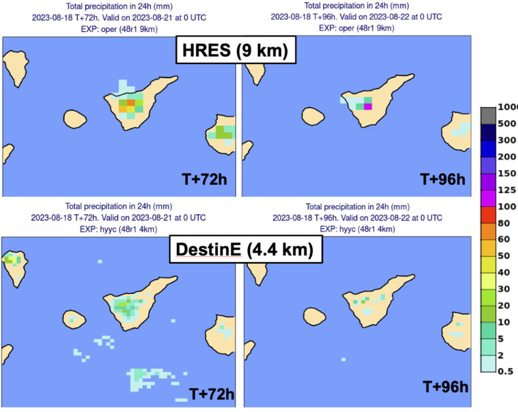
Regarding extreme precipitation, the evaluations showed that the forecasts of the Extremes DT at 4.4 km improve some known issues found in the ECMWF operational 9 km forecasts. In the case of convective precipitation over small islands with a complex orography, the operational forecast can sometimes overestimate extreme precipitation, creating false alarms. This phenomenon can be attributed to the strong moisture convergence induced by the pronounced topography of the islands, which affects the closure of the convection scheme.
The DestinE Extremes DT reduces such “false alarms” by better resolving the orography at 4.4 km resolution. The number of “rain bomb” false alarms in the Spanish island of Tenerife has for example been considerably reduced in the Extremes DT.
The simulations of the global component of the Extremes DT have also been proven to better predict maximum peaks of precipitation in orographic environments such as the Alps.
The reduced cloud base convective mass flux mentioned before is also expected to contribute to solve some other known issues of the Extremes DT at 4.4 km, by shifting marine convection further inland or by reducing the underestimation of extreme convective precipitation.
The evaluation also detected some deficiencies capturing very specific events, that are the object of further examination and experimentation. For some of them the DestinE scientists have already some leads to implement solutions.
Destination Earth is a European Union-funded initiative launched in 2022, with the aim to build a digital replica of the Earth system by 2030. The initiative is being jointly implemented under the leadership of DG CNECT by three entrusted entities: the European Centre for Medium-Range Weather Forecasts (ECMWF), responsible for the creation of the first two ‘digital twins’ and the ‘Digital Twin Engine’, the European Space Agency (ESA) responsible for building the ‘Core Service Platform’, and the European Organisation for the Exploitation of Meteorological Satellites (EUMETSAT), responsible for the creation of the ‘Data Lake’.
We acknowledge the EuroHPC Joint Undertaking for awarding this project strategic access to the EuroHPC supercomputers LUMI, hosted by CSC (Finland), and the LUMI consortium, Marenostrum5, hosted by BSC (Spain) Leonardo, hosted by Cineca (Italy) and MeluXina, hosted by LuxProvide (Luxembourg) through a EuroHPC Special Access call.
More information about Destination Earth is on the Destination Earth website and the EU Commission website.
For more information about ECMWF’s role visit ecmwf.int/DestinE
For any questions related to the role of ECMWF in Destination Earth, please use the following email links:


