

Pilot Service Dynamic Line Rating
Improving the Dynamic Line Rating energy transmission applications.
The Royal Meteorological Institute of Belgium (RMI) is developing and operating a Pilot Service using Destination Earth digital twin data demonstrating how high-resolution weather information can benefit operations of high-voltage transmission lines and grid planning. The Pilot Service is currently in the final stages of integration into the Destination Earth Platform.
Main contractor: Royal Meteorological Institute of Belgium (RMI)
Consortium: GeoSphere Austria, PropheSea, Elia
What is it? The capacity of electrical transmission lines depends on environmental conditions. With adequate weather information, energy operators can better exploit available transmission capacities by estimating actual capacity margins dynamically.
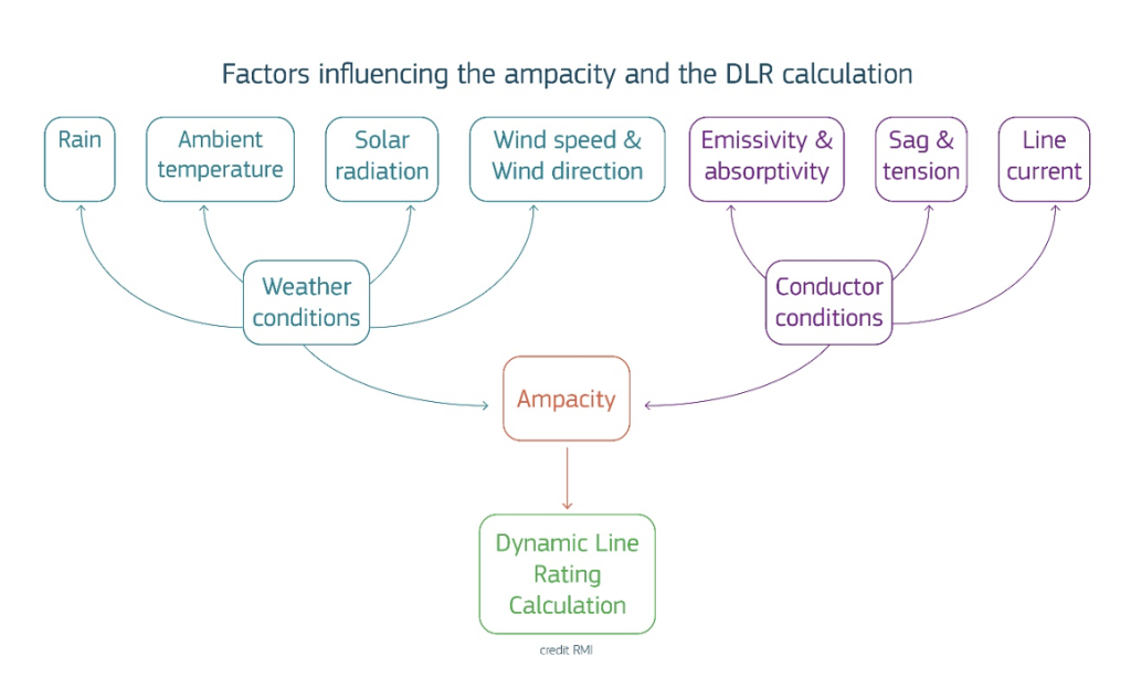
The Pilot Service extracts high spatial and temporal resolution data from the Weather-Induced Extremes Digital Twin (Extremes DT) to improve Dynamic Line Rating (DLR) energy transmission applications. The service delivers meteorological forecast parameters relevant to conductor thermal balance — including temperature, wind speed and direction, solar radiation, surface pressure, and humidity — at pylon height along user-defined transmission corridors.
Main target end users:
Energy transmission and energy grid operators, infrastructure planners and decision makers.
Digital twin data for energy transmission system operators
The enhanced level of granularity offered by Destination Earth’s Weather-Induced Extremes Digital Twin (Extremes DT) helps energy operators to better exploit the potential of the DLR approach.
The Pilot Service can help better use existing grid infrastructures and thus help economise on costly infrastructure investments such as the deployment of sensors in overhead lines or the reinforcement of the grid, thanks to the increased overhead lines ratings.
The Pilot Service applies an International Council on Large Electric Systems (CIGRE)-based multi-parameter algorithm to classify meteorological conditions along transmission corridors on a five-point scale from very unfavourable to very favourable. For ensemble forecasts, K-means clustering reduces the 51-member ensemble into representative scenarios, enabling risk-stratified assessments. This scoring could be used to trigger on-demand ~500 m resolution forecasts from the Extremes DT.
The end-to-end data pipeline connecting the on-demand Extremes DT to the service via the DestinE Platform’s Polytope API is set up, with automated hourly data ingestion, GRIB parsing, and spatial interpolation to user-specified coordinates.
Based on validation against local sensor data, the service prioritises robust favourable/unfavourable DLR condition classification rather than precise ampacity computation, aligning with ENTSO-E evaluation frameworks.
Results
Case studies with European TSOs demonstrate potential capacity increases of versus static ratings during favourable conditions.
Project Update
The Pilot Service went live in December 2025. The consortium has been consolidating the end-to-end data pipeline and is currently completing an intensive validation cycle with European transmission system operators. These case studies demonstrate that high-resolution hectometric forecasts can unlock significant additional transmission capacity compared with static seasonal limits during favourable weather, while maintaining strict safety margins. A key learning from direct sensor validation is that standard IEEE and CIGRE engineering formulae carry large inherent uncertainties; the service has therefore pivoted toward providing robust favourable/unfavourable Dynamic Line Rating condition scores rather than precise ampacity values. The connection to the DestinE Platform via the Polytope API is now fully operational, enabling automated hourly data ingestion. Structured feedback from end users has driven service refinements, and the team is now engaging additional operators through targeted demonstrations. A scientific paper detailing the methodology and results has been presented at the EnInnov 2026 conference.
Partners
- RMI — lead contractor
- GeoSphere Austria — national weather service; compound event detection and case studies
- PropheSea — project coordination, service architecture, and user engagement
- Elia — Belgian TSO; primary validation partner
About
The Pilot Service builds on prior DestinE developments, including the regional component of the Extremes DT at sub-kilometre scale and digital twin engine workflows on HPC systems.
Pilot Service contracts aim at demonstrating the added value of the DestinE Digital Twins and the wider DestinE System. The contracts include specific actions for machine learning and artificial intelligence-based solutions as part of the implementation of ML/AI techniques within the Destination Earth initiative of the European Commission, led by DG CNECT, and implemented by ECMWF, EUMETSAT, ESA and over 100 partner institutions across Europe.