Changes in the Water Cycle
September 2022 - April 2024
Providing global estimates of river runoff and freshwater availability to support climate adaptation measures.
In a nutshell
- Assessing water availability is key to adapt to water-related disasters and formulate mitigation policies.
- The use case aimed to refine the current hydrology information system by providing more refined estimates of river runoff.
- Thanks to the developed application, it was possible to obtain a greater understanding of the water availability and the measures needed for climate adaptation
Technical Overview
- Use Case Topic: Hydrology
- Scale of the Use Case: Global
- Policy addressed: Climate adaptation
- Providers: CSC-IT Center for Science
Challenge
Climate change is affecting the hydrological cycle and exacerbating water scarcity worldwide. Such water-related disasters as torrential rains, droughts and floods have been increasing both in frequency and intensity. With the raising hydro-hazard impacts, decision-makers require an improved scientific basis for preparation and response to the future extreme hydrological events.
DestinE Solution
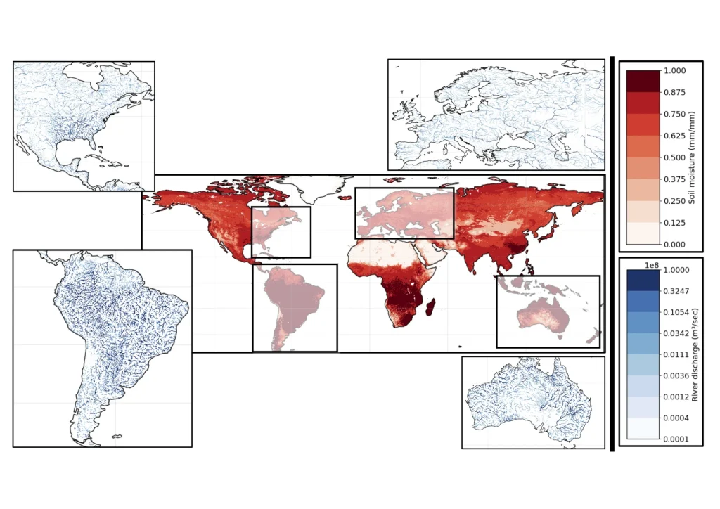
With this use case the Climate DT was able to provide global estimates of river runoff at a spatial scale of 5 km spatial scales and up to 1 hour, substantially more detailed than the current hydrology information systems. The HydroRiver application was based on the mesoscale Hydrologic Model (mHM), a well-established model used operationally by the German Drought Monitor, and the multiscale Routing Model (mRM), both developed by Germany’s Helmholtz Centre for Environmental Research (UFZ). The main users were DVGW (German Technical and scientific Association for Gas and Water) and EEA (European Environment Agency).
The mHM is used operationally by ECMWF in delivering the Copernicus Climate Change Service (C3S) to provide global seasonal hydrological forecasts and has also served for research, among others, about the impacts of climate change in flooding and droughts in Europe.
The application consisted of a “wrapping” software built around the mHM model that makes the interface with the climate DT and adapts the model to the global scale with the spatial and temporal resolution required.
Impact
The “HydroRiver” application provided data about a wide range of hydrological variables and indicators depicting global freshwater availability and providing insights on the requirements for climate adaptation from global to local level in areas of particular interest.
The enhanced global river discharge application processed enormous data rates resulting from the ever-evolving DT Climate simulations, as well as additional calculations for bias correction, which are critical on applications running at such spatial and temporal scales.
The system also provided hydrology information tailored for the impact sector with expert users and stakeholders participating in the process.