
Pilot Service – Tide and Surge Forecast, Flood forecasting in Philippines and Global Ship Route Optimization
Tide and surge global forecasts, flood forecast for Philippines
Main contractor: Deltares (Netherlands)
What is it? Combining data from the Weather-Induced Extremes Digital Twin (Extremes DT) and Deltares’ Global Tide and Surge Model (GTSM) and the Global Storm Surge Information System (GLOSSIS), Deltares will develop:
- A Global Tide and Surge Forecast pilot service to provide high-resolution forecasts of water levels, storm surge and currents
- A compound flood impact forecasting pilot service for Philippines
- A Global Ship Route Optimization pilot service gathering key information for shipping
Concrete applications examples:
- Data-scarce coastal regions will be provided with accurate storm surge, tide, currents forecast for flood risk management and maritime applications
- Compound flood impact forecasts are generated based on Deltares SFINCS models, combined with coastal water level from GLOSSIS and river discharge information from the GLOFAS system to support early warning of flooding risk.
- Shipping operations can be optimised for reduced fuel emissions
Main target end users:
- Flood risk emergency management services and decision makers
- Shipping industry owners, operators and professionals
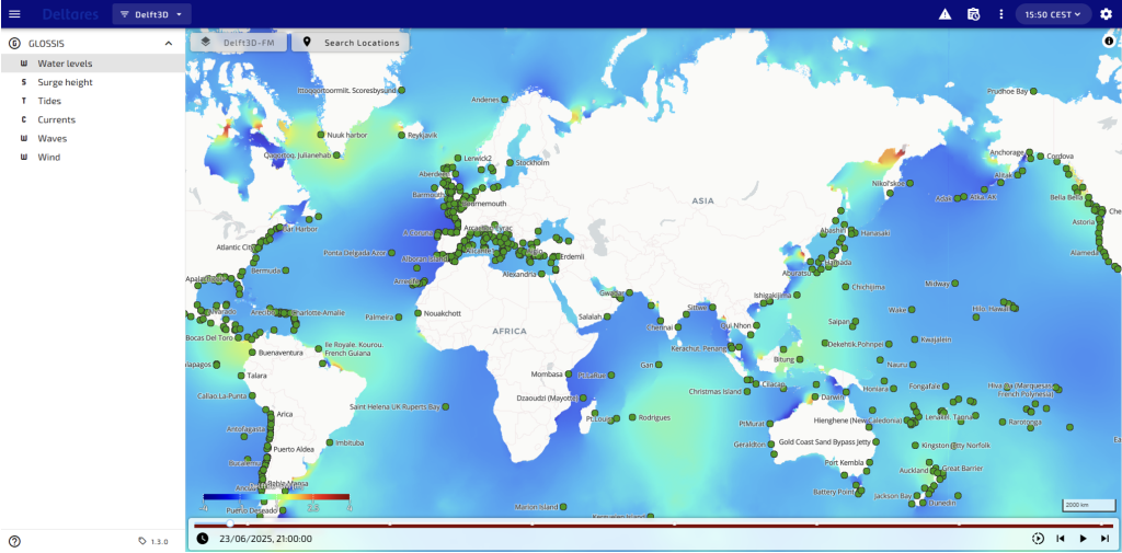
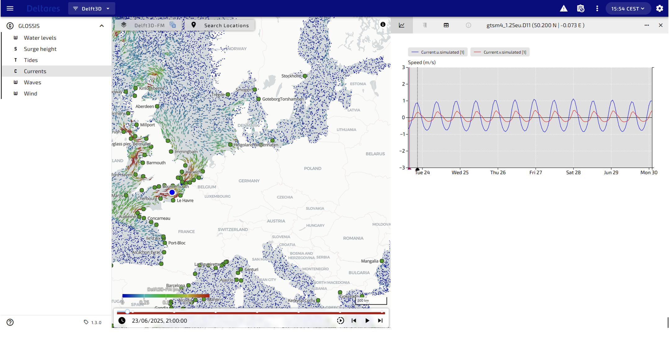
Digital twin data for global tide, storm surge and current forecasts
The specialist institute Deltares, from the Netherlands, will lead a team including 510 Netherlands Red Cross and Made Smart Group to exploit Destination Earth (DestinE) digital twins’ data for building three pilot services related to coastal areas. The core service is a Global Tide and Surge Forecast pilot service providing high-resolution forecasts of water levels and currents, extremely important for low-lying data scarce coastal areas. In addition, the team will develop a downstream pilot service for predicting compound flooding impact in the Philippines and a Global Ship Route Optimization pilot service that will provide key information for safer and more efficient global shipping operations.
For the Global Tide and Surge Forecasts Deltares will rely on the Global Tide and Surge Model (GTSM), with a spatial resolution up to 1.5 km for Europe, 2.5 km globally and a coarser resolution as it moves away from the coast up to 25 km in the deep ocean leveraging inputs from the global component of the Weather-Induced Extremes Digital Twin (Extremes DT) and demonstrating the added value of this approach.
The pilot service aims to produce accurate forecasts for over 16,000 coastal segments and 40,000 locations globally. The service is particularly suitable for data-scarce regions, supporting early warning and disaster risk reduction in line with the United Nations’ Early Warning for All initiative.
In the Philippines, an area with an extensive coastal area particularly vulnerable to extreme weather and coastal flooding, the downstream pilot service will create a nationwide coastal hydrodynamic model, integrated within the GTSM, that will provide detailed coastal storm surge forecasts. The service will also integrate Deltares’ fast numerical compound flooding SFINCS enabling accurate compound flood forecasts for the archipelago. All models will be integrated into Deltares’ forecasting platform, Delft-FEWS, to ensure the timely generation of forecast information. Flood early warnings will be disseminated via 510`s Impact Based Forecasting (IBF) portal. The Philippine Red Cross, START Network, PAGASA and Project NOAH will be the key users of the pilot service allowing them to better predict and respond to flood impacts by activating Early Action Protocols to protect vulnerable communities during tropical cyclones. The Pilot Service builds on the developments of the use case on Disaster Risk Mitigation implemented during Phase I of DestinE.
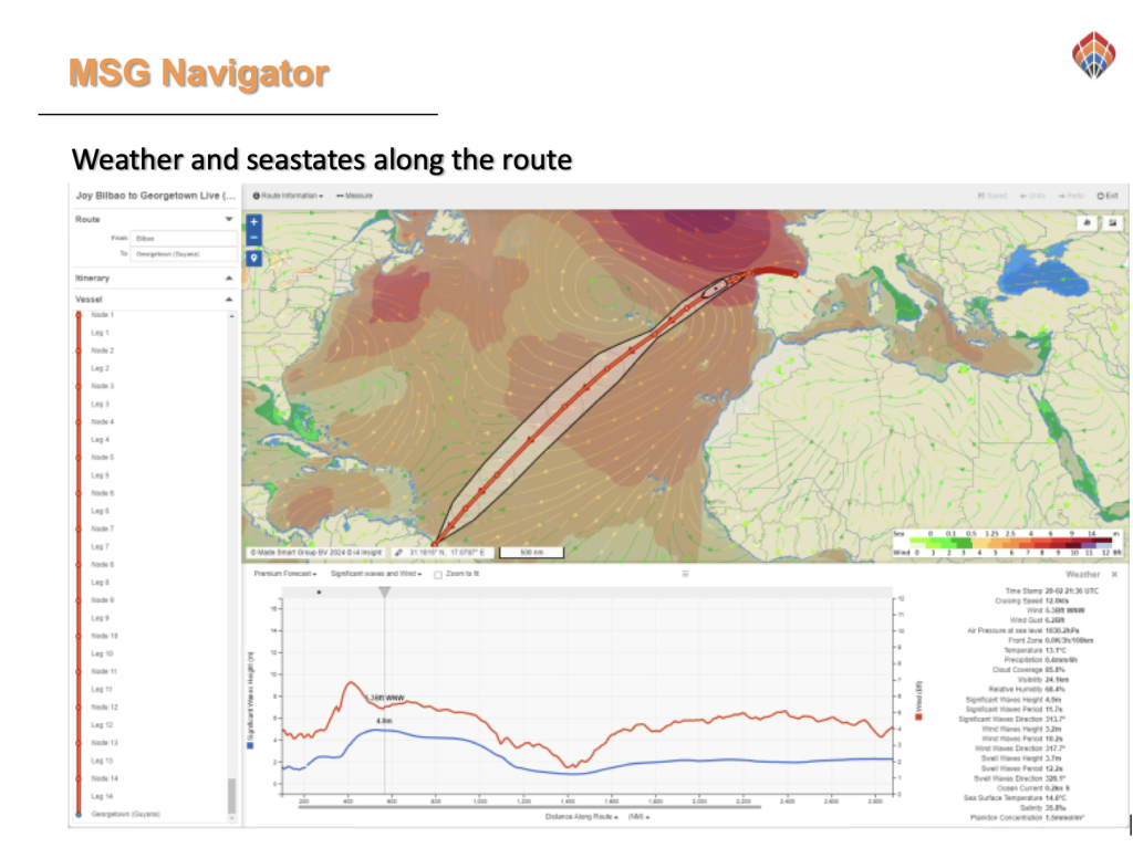
The Global Shipping Route Optimization pilot service will integrate GTSM and Extremes DT forecasts into shipping route planning systems. With the enhanced data on forecast tides and weather conditions the shipping industry will be able to reduce their environmental footprint with more efficient routing and reduced risk of accidents.
Deltares is an independent knowledge institute in the Netherlands, specialised in innovative solutions in the field of water and subsurface. It has been involved in DestinE during Phase I with a use case on Disaster risk mitigation and climate adaptation, and Adaptation Modelling Framework.
ECMWF, as a key implementing entity of the Destination Earth initiative of the European Union, has issued a series of pilot services contracts that demonstrate the added value of the Weather-Induced Extremes Digital Twin and the Climate Change Adaptation Digital Twin, and the wider DestinE architecture. The key target users of the pilot services are the sectors most impacted by climate change and weather extremes, such as maritime operations, coastal areas, energy, and more. The contracts include a specific call for machine learning and artificial intelligence-based proposals as a part of the implementation of ML/AI techniques within the Destination Earth initiative of the European Commission, led by DG CNECT, and implemented by ECMWF, EUMETSAT, ESA and over 100 partner institutions across Europe.
Copyright title image: AdobeStock Vibu design gallery