Developing machine learning (ML)-based Earth system model components is central to the AI activities implemented by ECMWF and their partners within the Destination Earth (DestinE) initiative of the European Commission. This blog series shares insights from experts building these components, highlighting their approaches and contributions towards a coupled ML-based Earth system model.
aiLand – emulating land surface processes

By Nina Raoult, ECMWF Scientist – aiLand team
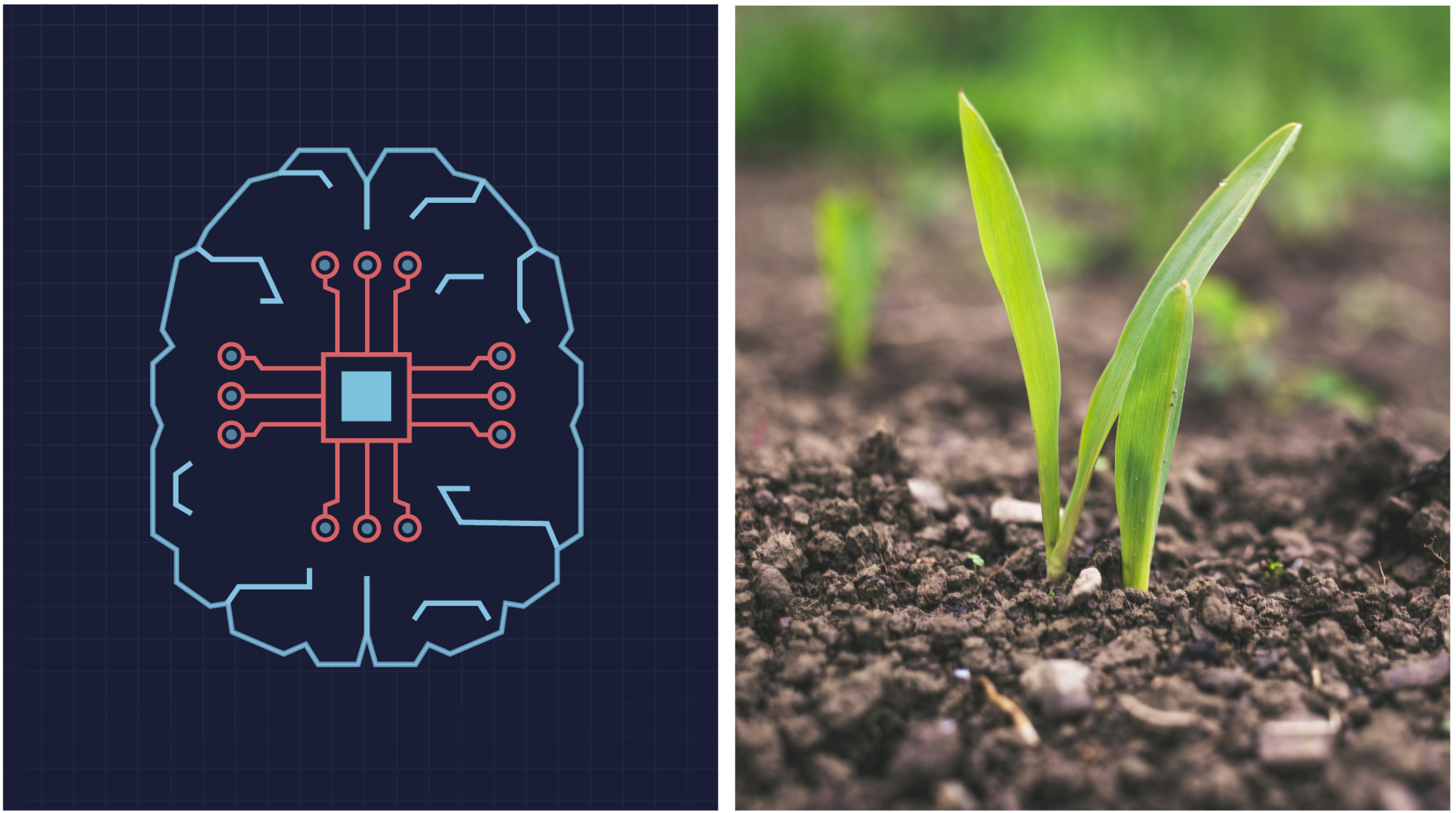
Land surface processes shape the way we experience weather and climate in our daily lives. They influence how much water is available for farming, how severe a drought becomes, how long snow lasts in the mountains, and even how hot cities feel during a heatwave. These processes govern the exchange of heat, moisture, and energy between land and atmosphere, affecting everything from food security to water management and outdoor activities. However, modelling land–atmosphere interactions remain a major challenge. The land surface is highly varied and shaped by complex processes that cannot easily be captured by simple formulas.
aiLand is a global deep learning model developed at ECMWF to emulate key land surface processes. Trained on data produced with ECMWF’s state-of-the-art physical model, it has learned how different landscapes respond to changing weather. This enables aiLand to deliver reliable predictions across a wide range of climates and terrains at a fraction of the time and computational cost of physics-based models.
Starting with the surface
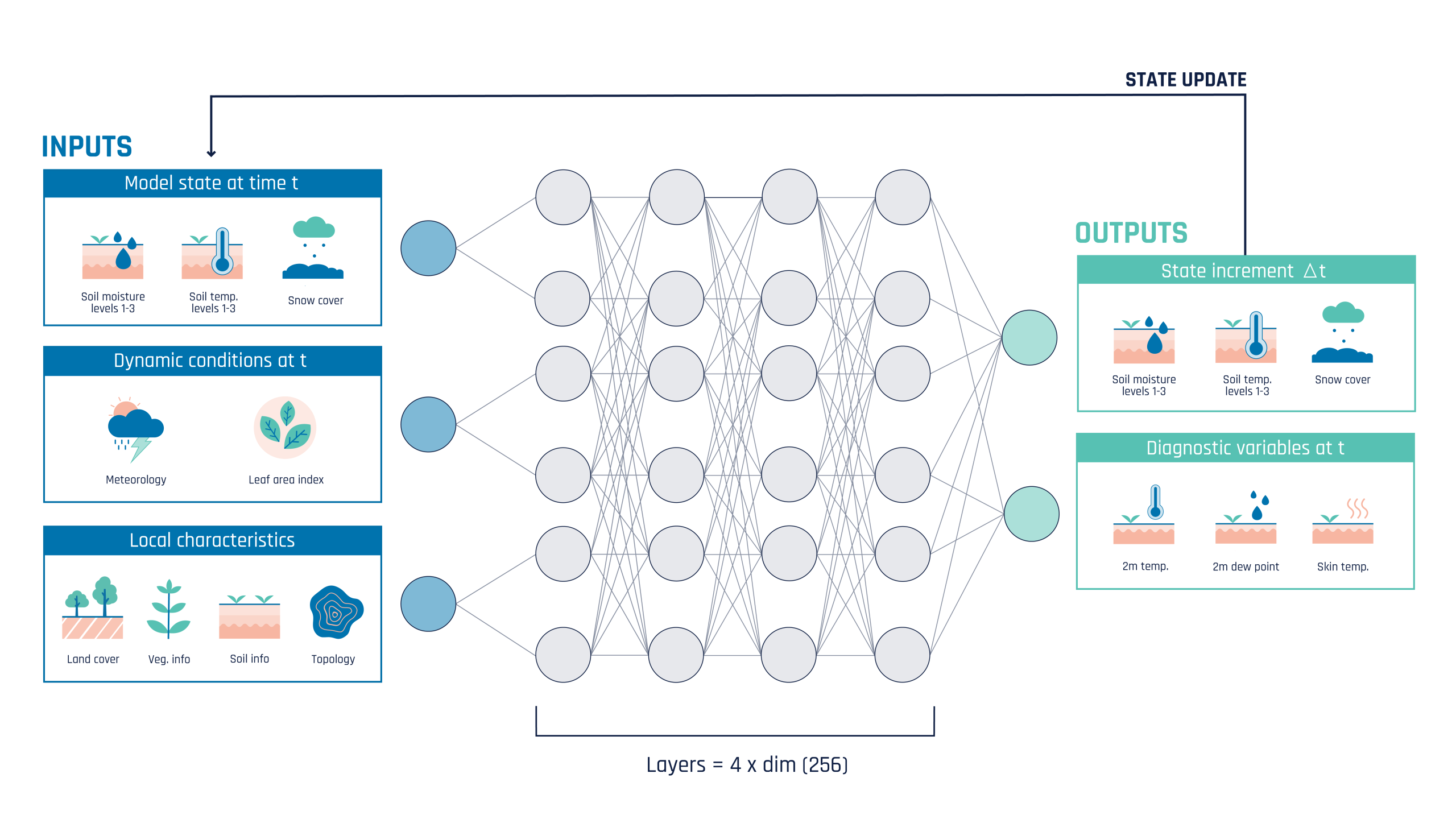
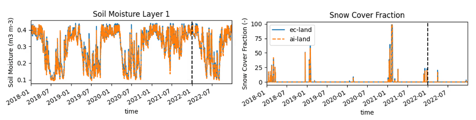
Land surface processes shape the water and energy cycles that drive our weather and climate. To start with, aiLand has been trained on soil moisture, soil temperature, and snow cover—key variables that strongly influence heat and water exchanges, respond directly to rainfall and temperature, and are relatively well observed. By learning these fundamental states, aiLand can capture how the land responds to weather and lay the groundwork for modelling more complex processes across diverse landscapes.
How aiLand learns
aiLand uses a multilayer perceptron (MLP) neural network; a flexible model that learns complex relationships between meteorological inputs and local land surface states. The model is resolution-agnostic, meaning it is able to handle data and make predictions at any spatial scale. During training, aiLand learns how precipitation, near surface temperature, and other atmospheric forcing inputs—together with local characteristics such as land cover and topography—translate into updates of soil moisture, soil temperature, and snow cover, as well as predictions of air temperature, dew point, and Earth skin temperature. The model is trained on 6 hourly outputs of ecLand, ECMWF’s physical land surface model, over the years 2010-2021 and evaluated against 2022.
How well does it work?
Initial results show that aiLand reproduces the key behaviour of ECMWF’s physical model with remarkable speed and accuracy, both in time and space. Even when aiLand is initialised just once at the beginning of a simulation (i.e., giving it the model’s starting conditions), it can run for many years and still produce results that closely match the physical model.
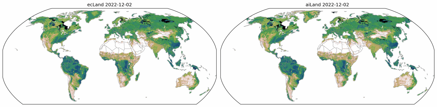
physical model on the left, aiLand model on the right
A tool for model improvement
aiLand is not only a predictive tool—it can also help improve physics-based models. By comparing its results with physics-based models and observations, we can use this tool to identify where the physical models might be improved. In this way, aiLand acts as both an emulator and a diagnostic tool, supporting the development of next-generation Earth system models.
aiLand is also highly relevant for data assimilation, the process of combining model output with observations to create the best possible estimate of the current state of the Earth system. Because it is fast and flexible, aiLand can be used in ensemble approaches that require many simulations, and it can emulate tangent-linear and adjoint models, which are key components in advanced data assimilation frameworks. This makes it a powerful resource for improving how we monitor and understand the land surface and its role in the climate system.
What’s next?
This work represents the first step toward a fully data-driven land surface model, developed under the Destination Earth initiative of the European Commission. We have shown that AI can be successfully trained on physical land-surface models to predict soil moisture, soil temperature, and snow cover. Future developments will expand aiLand to include processes like vegetation dynamics and explore coupling strategies with other Earth system components from Destination Earth and with ECMWF AIFS. Over time, this type of machine-learnt land surface model could support practical applications in agriculture, water management, and climate adaptation.
Authors
Nina Raoult and Ewan Pinnington, on behalf of the Land Modelling, Coupled Data Assimilation and Machine Learning teams at ECMWF. The authors would also like to thank the team behind Anemoi, which provides a complete toolkit for developing data-driven weather models—from data preparation through to inference—as well as our colleagues working on other ML–Earth System components at ECMWF, within the framework of Destination Earth, for their technical advice and support.
Destination Earth is a European Union funded initiative launched in 2022, with the aim to build a digital replica of the Earth system by 2030. The initiative is being jointly implemented by three entrusted entities: the European Centre for Medium-Range Weather Forecasts (ECMWF) responsible for the creation of the first two ‘digital twins’ and the ‘Digital Twin Engine’, the European Space Agency (ESA) responsible for building the ‘Core Service Platform’, and the European Organisation for the Exploitation of Meteorological Satellites (EUMETSAT), responsible for the creation of the ‘Data Lake’.
We acknowledge the EuroHPC Joint Undertaking for awarding this project strategic access to the EuroHPC supercomputers LUMI, hosted by CSC (Finland) and the LUMI consortium, Marenostrum5, hosted by BSC (Spain) Leonardo, hosted by Cineca (Italy) and MeluXina, hosted by LuxProvide (Luxembourg) through a EuroHPC Special Access call.
More information about Destination Earth is on the Destination Earth website and the EU Commission website.
For more information about ECMWF’s role visit ecmwf.int/DestinE
For any questions related to the role of ECMWF in Destination Earth, please use the following email links: